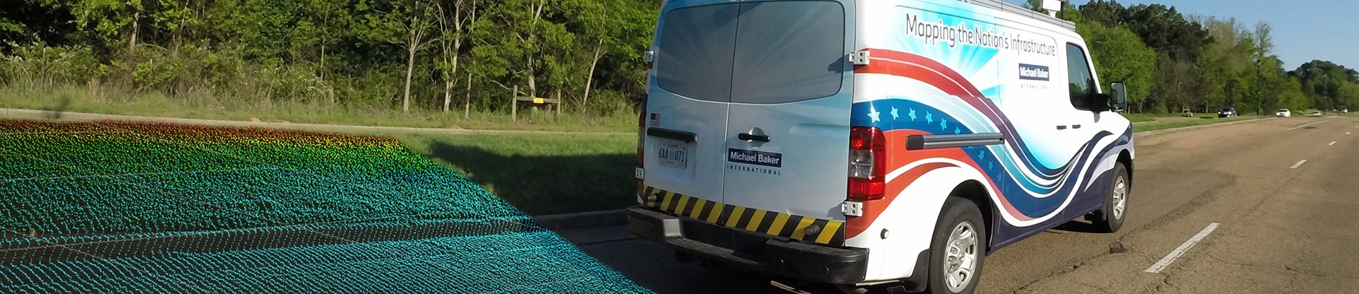
Michael Baker uses mobile light imaging, detection and ranging (LiDAR) to create a 360-degree immersive experience to evaluate infrastructure needs
From the Winter 2018/2019 issue of Signature
The nation’s leading telecom providers use it for richly detailed maps that enable them to design fiber-optic infrastructure for their most up-to-date networks.
The Pennsylvania Turnpike Commission has deployed it to assemble a federally mandated pavement inventory that allows the agency to identify and repair trouble spots in a timely fashion.
The world’s busiest airport has relied on it for a series of upgrades that have enabled the facility to accommodate new flights and create a more satisfying customer experience.
What all these major players are using is terrestrial laser technology, leveraging important breakthroughs in scanning, imaging and mapping technologies that provide more detail – at greater resolution – than conventional methods. The common thread is that they have all relied upon Michael Baker International as a key partner for their innovative mobile solutions.
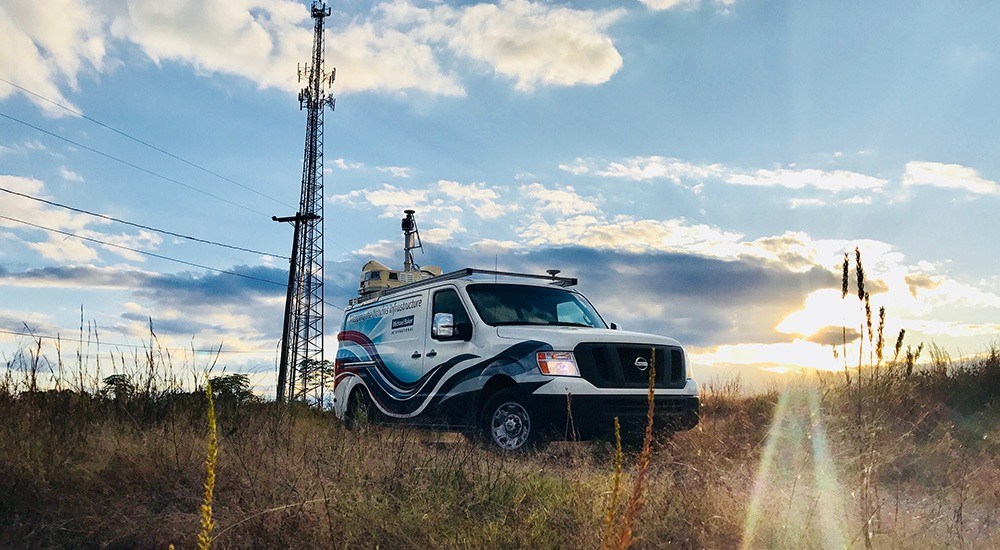
One of these solutions is LiDAR – an acronym for light imaging, detection and ranging (or light detection and ranging). Sometimes called laser scanning or 3D scanning, LiDAR is a surveying method that measures distance to a target by illuminating it with pulsated laser light and capturing reflected pulses with optical sensors. The differences in laser return times and wavelengths are then used to fashion digital 3D representations of the target. Think of LiDAR as radar with laser beams instead of radio waves – and with vastly higher precision.
While static LiDAR units are typically fixed to tripods that are traversed through a project area, Michael Baker’s solution leverages technological advancements in sensor design to mount lasers on vehicles, thus creating Mobile LiDAR, which also incorporates a spherical array of six cameras to create a 360-degree immersive experience. Pushing the innovation envelope further, Michael Baker integrated a high-resolution Laser Crack Measurement System (LCMS™) to automatically measure, detect and quantify all key functional parameters of pavement, including cracking, rutting, texture, potholes, shoving, raveling and roughness.
“We are not just capturing a representation of what is there. We are creating a one-to-one scale model of the real world,” says Aaron Morris, GISP, associate vice president in Michael Baker’s Jackson, Miss., office, and has been with the Company for 22 years. “Moreover, it brings the added benefit of increased worker safety and, by operating at posted speeds, completely eliminates the need to block lanes or impact traffic.”
With four Mobile LiDAR systems, Michael Baker collected data on more than 7,500 miles of roadway corridor over the course of six months in the major markets of Charlotte, Chicago, San Diego and the San Francisco Bay Area, and within communities spanning a population of roughly 3.5 million and comprising over 300,000 utility poles. The information gathered is not only helping current clients, but it is also building a portfolio for the development of “Smart Cities,” where 5G data networks link and allow for management of transportation, emergency response, utilities and health care services. It is a vital new approach that brings multiple information and communication technologies to bear on community involvement, administration and improvement.
Here is a look at some of Michael Baker’s most far-reaching innovative deployments:
IMAGES & DATA FOR TELECOM COMPANIES
When telecom providers need to locate, design and install fiber-optic infrastructure for new 5G networks – whether aerial or underground – they require detailed, precise maps to guide them. Michael Baker works with the nation’s largest telecom providers to deliver that information.
“We capture everything within line-of-sight up to 200 meters as we drive down a given roadway,” Morris says. “Our processing teams render detailed planimetrics such as paint striping, curbs, sidewalks, mailboxes and street furniture for planning and permit maps, as well as comprehensive 3D models of every utility pole. It is important for make-ready and construction details to be accurate for attaching fiber cables or antennas to utility poles. Our approach enables efficient collaborative design, accelerating cost-effective deployment of 5G.”
It is those deliverables that set Michael Baker’s Mobile LiDAR solutions apart. Because Mobile LiDAR requires fewer “boots on the ground” than traditional methods, the Company can focus its efforts on processing, analyzing and rendering “Big Data.”
“Our solution is inversely proportional to conventional methods,” Morris notes. “Those are heavy in the field and manually rendered in the office. Our LiDAR-based approach can produce up to 100 miles of data per vehicle every day with only two field staff and leverage intelligent tools to generate deliverables.”
To build modern new networks, telecom providers must often set new poles or coordinate load-balancing on existing poles. For that task, Michael Baker’s One Touch Make Ready (OTMR) product line, OTMRdata®, is invaluable.
“Every object on every pole needs to be identified so service providers can perform pole-loading analysis” Morris says. “They will run theoretical models to assess for wind load and ice load and tensioning to determine if they need to modify a pole to hang new fiber.”
Through a suite of proprietary software, including POLEmapper®, POLEdata®, and POLEexporter®, the Michael Baker team analyzes and shapes data so that clients can complete pole-related tasks on time and in compliance with new federal regulations for OTMR.
SURVEYING AN ENTIRE TURNPIKE WITHOUT LEAVING YOUR VEHICLE
What would happen if, instead of focusing on the passing landscape, you directed your lasers and cameras to the ground as you drove over it? You would have an innovative way of surveying the condition of the roadway itself. The technology is a bit more sophisticated than that, as Michael Baker’s pavement condition solution includes the LCMS as well as an inertial profiler – or “rut bar.”
“The general principles are the same,” says Stephen Clancy, PLS, GISP, associate vice president for Michael Baker’s LiDAR operations, “but the pavement system users lasers only focused on the roadway. The resolution and precision of these downward-firing lasers are much finer on the pavement system as it needs to detect thin cracks and surface defects.”
For the past three years, Michael Baker has deployed this cutting-edge technology to help the Pennsylvania Turnpike Commission (PTC) assess the condition of its mainline and all related ramps and interchanges (over 1,300 miles). The Company’s specialized vehicle can scan about 150 miles per day, meaning the mainline survey is captured in only seven days, and the complete picture of the turnpike (including roaming the turnpike system to acquire 258 addition miles of its extensions and ramps) takes an additional 12 days to produce. Justin Furch, Michael Baker’s technical manager of GIT in the Hamilton, N.J., office, observes that the vehicle does its work at highway speed.
“That is the beauty of it,” he says. “Operators can remain in the vehicle as data is collected at highway speed. It is a big safety plus.”
Michael Baker has developed customized software applications to perform data extraction, processing and exporting of information to fit virtually any client need, including PTC’s.
“We collect raw information of every single crack, crevice and pothole on the road,” Furch says. “After the field data is collected, we have custom-developed software tools that will export the data into formats that the commission is looking for. We provide a series of spreadsheets and text files, which feeds into their asset management system that supports scheduling of paving projects.”
The software enables calculation of the turnpike’s International Roughness Index (IRI) and other metrics that align with PennDOT’s Pub 336 specifications. This information helps PTC highlight problem areas and can be used when prioritizing areas for repair or rehabilitation, benefiting motorists who are able to travel more safely and with fewer delays. In addition, Michael Baker delivers the data to PennDOT so that it can comply with federal reporting requirements.
Says Furch: “One of the reasons these is such a big push for these types of pavement services is that the Federal Highway Administration requires state agencies to submit this information so that it can make a national assessment.”
Indeed, thanks to that emphasis, other agencies are seeing the benefit of Michael Baker’s pavement solutions, including a multi-year, 26,000-mile statewide pavement assessment for the West Virginia Department of Transportation Division of Highways and similar services for Morris County and Camden County, N.J.
UPGRADING FACILITIES, PASSENGER AMENITIES AT HARTSFIELD-JACKSON
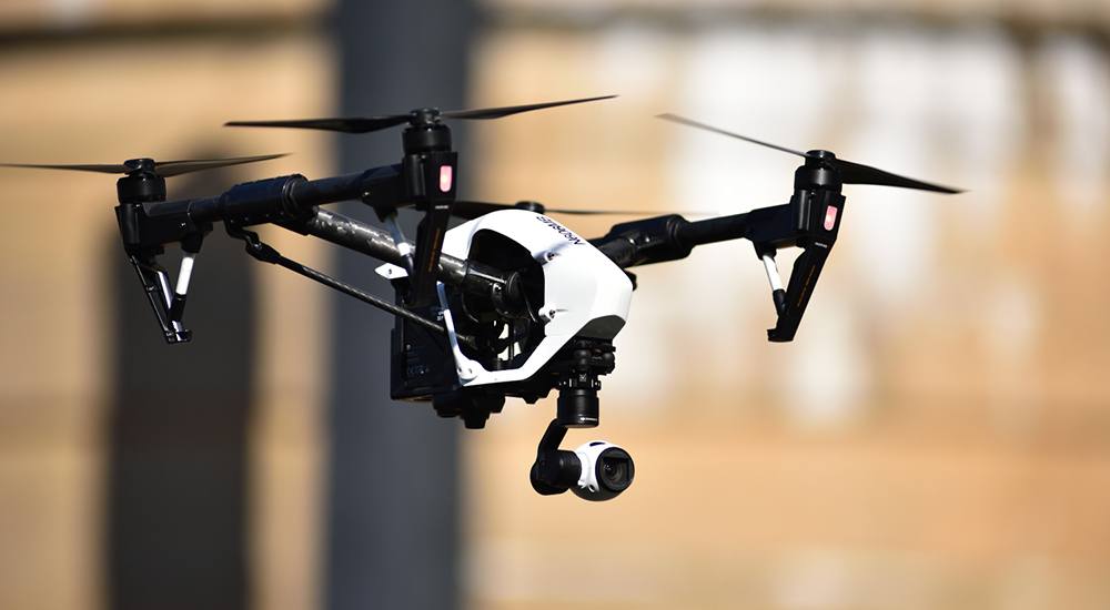
In 2017, 104 million passengers passed through Hartsfield-Jackson Atlanta International Airport, a number that is unmatched in the world. With that kind of volume, an important emphasis for the airport is upgrading facilities and passenger amenities. Michael Baker and its joint venture partners – Pond & Company and CERM – have collaborated with the airport on a number of initiatives that featured use of both Mobile LiDAR and static LiDAR, as well as Michael Baker’s expertise in small unmanned aircraft systems (UAS).
One of those important projects occurred when Hartsfield-Jackson needed to widen runways and taxiways 15 feet to accommodate the new Airbus A380 and its capacity of more than 800 passengers. The joint venture used Mobile LiDAR to assess the runways and taxiways and survey the entire area for widening.
Reports Quinton Watkins, P.E., senior civil engineer of aviation for Michael Baker and program manager and principal for the Atlanta airport project:
“We produced a drawing showing the contours to determine the obstructions in the 15-feet extensions and where water would drain properly. We were able to work at night and complete the survey in a single shift, so there was no disturbance to plane traffic or passengers.”
In addition, the airport asked Michael Baker, through the joint venture, to provide a Mobile LiDAR scan of the facility’s complete work of roadway signage that guides visitors entering or leaving the airport. Brian HAren, geospatial program coordinator for Atlanta’s Department of Aviation, indicates the airport utilized the resulting information and images in several ways.
“We used the data for 3D modeling,” Haren says, “and we also entered it into a database that uses industry signage codes. It gives our signage group a tool that is being tied into our consolidated maintenance management system that will allow them to generate service requests to have signs changed, repaired or updated.”
Using static LiDAR, Michael Baker performed a similar survey of the lengthy corridor international passengers must traverse to reach customs check-ins. Explains David Wright, geospatial engineering program manager for the aviation department at Hartsfield-Jackson:
“It is a long, sterile corridor that does not offer any concessions. The idea was to capture that in an accurate, representational way so that we can improve wayfinding and the overall customer experience. We are considering various options now.”
Wright says the impact of LiDAR on airport operations, even beyond specific projects, has surprised him.
“It turned out to be so much more than what we originally expected, as we have introduced the technology and usability through web interfaces,” Wright says. “Our architects and signage and management staff have quickly learned that they can do on-site discovery without having to physically go into the field. That is a pretty powerful tool.”
Finally, in May 2017, the airport teamed with the joint venture for an initiative that involved surveying a portion of a heavily trafficked runway to prepare a pavement distress assessment. For this project, Michael Baker tapped its UAS solutions, flying a pair of drones with sensors to capture Digital Surface Model (DSM) topographical imagery as well as video.
It marked the first time UAS was used to fly in Class B airspace surrounding the busiest airports used by jets and other aircraft. All aircraft traffic, including UAS, must be cleared for entry into this closely controlled airspace. The mission’s results were encouraging.
“The imagery is super-high resolution,” says Jim Duguay, Michael Baker’s manager of aviation planning who has been with the Company for nearly 20 years.
“The intent is to collect imagery with UAS of all the pavement at Hartsfield and provide that to engineers for inspection purposes. Right now, we are testing uses, procedures and deliverables.
“Without UAS, an inspection would close a runway for about four hours. We flew for about an hour, although we did not inspect the entire runway. But the theory is that UAS will reduce downtime.”
To follow up that historic mission, Duguay and the City of Atlanta are members of a panel that will work with the Federal Aviation Administration to develop regulations and processes for UAS at airports.
LOOKING AHEAD
In many ways, Michael Baker’s pioneering use of technology is helping government and commercial clients – across a broad range of sectors – imagine and implement community-serving initiatives. Just as importantly, the Company’s leadership in innovative scanning and surveying technologies is providing a stepping-stone for a future that is even more appealing.